Kane Creek Canyon is a trail that was highly recommended to us by a neighbor when staying at Canyonlands Campground in Moab.
“The only hard part is the climb out of the canyon, and that isn’t too bad” were the only words of hesitation.
So with reckless abandon, I hit the trail with friends Andy, Matt and Joe.
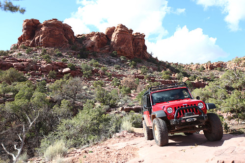
The trail follows Kane Creek Canyon road out of Moab, heading West. The road quickly turns to dirt and descends through a really nice canyon. The road was pretty dusty, so Matt in his JK had to drop back a bit.
Kane Creek starts out a little on the boring side. At least the scenery is amazing.
Eventually the trail appeared on the Left, across from the Kane Creek/Chicken Corners pull off.
The morning started early, with the crusty frost on the grass and the long morning shadows on the ground. The Wasatch mountains were cloaked in beautiful colors, and tiny birds filled the sky.
The Wasatch Mountains overlooking the Jeep.
After a conference call for work, some free OJ in the hotel lobby and a repack of the Jeep, we were on our way at 10:30AM. We hit the first Starbucks since Ohio, and celebrated our familiar caffeinated favorites with a cardboard clink and a toast for the road.
A quick stop at Starbucks – the first since Ohio.
Today would be the home stretch, a blessing in disguise. Knowing it would be our last day on the road was bittersweet, but knowing we had to push on – no more breaks – was a bit daunting.
We made our way out of Utah very quickly, the Idaho border arriving as a surprise. Following signs for Burley, I was able to calculate distance and time with the familiar scenes from our recent Moab trip.
The wide open expanses of Northern Utah.
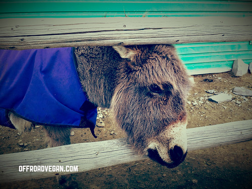
We ended up stopping for a gas up at a small gas station just off the highway, in the middle of nowhere. As we pulled in, a lone tumbleweed tried to warn us of the potential “Hills have Eyes” situation about to unfold.
Welcoming committee.
However, while we were never burned to the stake, we were greeted by some friendly donkeys and llamas as well as entertained by a very well laid out store ripe with western jokes and cold drinks.
OK, some were funny.
We stopped in Boise for a lunch break and to see an old friend for a cup of tea. Brandon suggested a vegan-friendly joint called the Shangri-La Tea Room and I was impressed with their vegan goodies. Right when you walk in the door, a display case teases you with a beautiful array of vegan donuts.
Vegan donuts. Yes and yes.
I ordered the vegan burger which was really good, and my sister got the tofu scramble (which she said was amazing). Brandon made it a tea-only affair. After lunch, I ordered a ton of donuts for the drive, and to take home for Melanie.
Ribbon of roadway.
These last 7 hours would be the longest of the trip. Idaho soon blended into Oregon at the Snake River and the Wallowas soon greeted us. Eastern Oregon has to be one of the most beautiful arid, stark places I have ever seen and it continues to astonish me each time we pass through.
Eastern Oregon
The headwind as we approached the Columbia gorge were unbelievable. The little Jeep still pushed 70-75 where possible, but the noise with the soft top was often unbearable. My Bose noise-canceling headphones proved helpful.
We left I-84 in Hood River, opting to circle Mt. Hood for a shorter drive home.
The dark, snowy (read: very snowy) drive was a beautiful end cap to our adventure. As we descended through Government Camp, Rhododendron, and finally home, we pulled in the driveway at about 10:30PM.
It was so great to be home. Being greeted by the dogs, seeing Melanie, and sleeping in my own bed was so amazing. But being on the road in a 15 year old Jeep was also amazing. With plenty of silent time to think and recollect it was almost more meditation than road trip.
We started in Lincoln, Nebraska after an amazing night’s rest and a break from the Jeep.
We filled up on gas, OJ and truck stop coffee before heading out on 80 West. It was a beautiful morning in Lincoln, with bluebird skies and warm temps.
Starting point for day 2.
Nebraska, while actually a really cool state, was my nemesis on this trip. The sheer size of this state, when coupled with the rather drab scenes, makes it a monotonous drive. There is, however a beauty in the stark flatness, combined with what seems like “small town” America. I want to visit Nebraska more, as long as I don’t have to drive across it.
Truck stop coffee: Actually not that bad, but no soy creamer 😦
The mile markers passed rather quickly toward Wyoming with little issue.
Toward the Western end of the state, the winds began to pick up, and pretty strong. Signs warned of empty trailers with 50+ MPH headwinds. The Jeep is not very aerodynamic, and the soft top made conversation and music pretty pointless.
Once we entered Wyoming (finally!) the winds were howling pretty crazy.
The I-80 corridor will always hold a special place in my heart. Melanie and I had plane tickets on 9/11 to attend her brother’s wedding in Iowa. With United rebooking us repeatedly and the FAA eventually restricting all flights, we had no more options.
Until I found a car to rent.
So we drove that little Mazda from Palo Alto, CA all the way to Burlington, IA. It took us 40 hours of straight driving and early relationship building. If two newly-dating people can survive that much time together in a car, well…maybe that explains our 11 year success with our marriage.
I-80 will always be a cool road for me.Sidney, Nebraska. Nowhere indeed.
The sun slowly slipped behind the mountainscape as we progressed through Wyoming. Looking out my driver’s side window I could not help but be mesmerized by the starry night sky. It was absolutely amazing.
The sun slowly sinking.
Making our way into Utah, we found a great place to crash for the night for our final push into Oregon.
No matter where you are, Jeeps are nearby.
VEGAN SITUATION:
As we head further West there are more Taco Bells when in a pinch. Along this corridor, that is honestly the best bet. We did not have time to go into supermarkets, so I have no idea what those were like, but I will remain pessimistic. Some truck stops have bananas and other goodies.
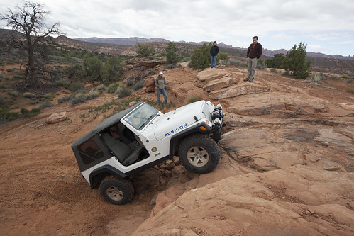
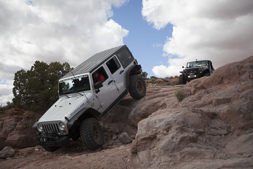
This trail was on my Moab Bucket List™ for a long time. A few of the climbs look pretty crazy, the views amazing, and conquering the famed “Hell’s Gate” was one of the reasons I came to Moab.
The sign at the trailhead for Hell’s Revenge. Click it for the high res version if you want to read it.
After a quick air down at the parking lot of Hell’s Revenge Jesse, Melanie and I were on the trail by 8:30.
The trail climbs almost instantly right from the staging area. In the first few minutes, you climb up onto a saddle, riding a narrow ridge – this is just a sample of what’s to come. At the base of this, is a narrow sandy area called “Lake Michigan” due to the potential for high water. It was wet on this day, but easily crossable.
The first ridge you will cross is immediately out of the parking lot.
The views open up into some pretty spectacular scenery. The trail is predominantly on slickrock with some sandy spots. The first couple of climbs will certainly get your heart rate going, especially when you see them in the distance – they look almost vertical. With a little throttle control and some alertness, it is fine. Continue reading Trail Report: Hell’s Revenge [Utah]→
One of my favorite aspects of running trails in Moab is that you can (usually) leave the doors off. Our jeep did not see doors the entire week.
But, this morning was a 6AM departure and a pretty long drive along the Colorado River. It was freezing. Some of the most beautiful scenery I have experienced in a long time. But freezing.
Route 128 follows the Colorado River for most of it’s length.The morning light was amazing off the canyon walls.
We started out pretty early, arriving at the trailhead about 8:00AM.
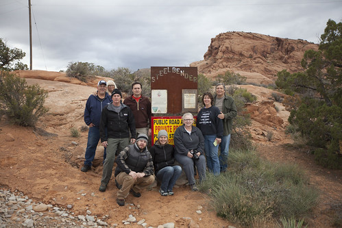
Quick group photo. Yours truly is taking the picture.
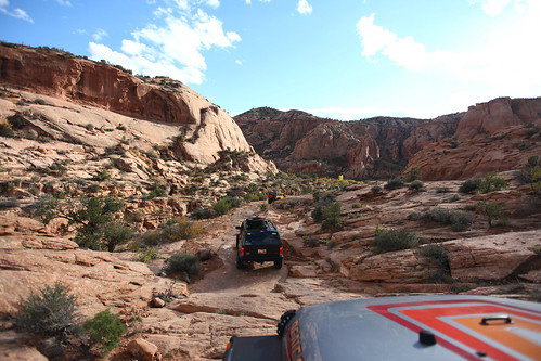
The team posed for a quick photo at the trailhead and we met up with a couple that asked if they could run the trail with us in their Cherokee.
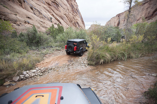
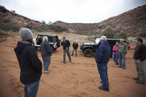
We drove in about 2 miles of pretty easy gravel road with a minor creek crossing, and took a break for a quick driver’s meeting. This was also a great opportunity to meet our new friends.
Minor creek crossing.Quick driver’s meeting.
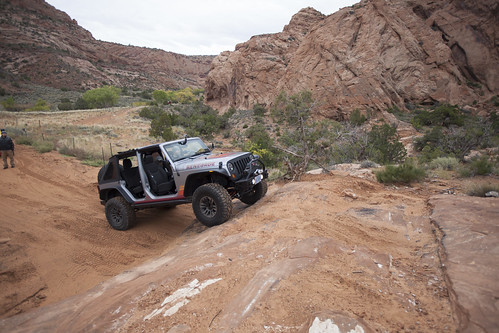
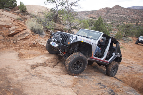
The area we stopped at was a “Driver’s Choice” section with many different lines of attack. I chose what I thought was a challenging ledge and was able to get up reasonably easy, even though the rock surface had some damp sand.
My challenging line.
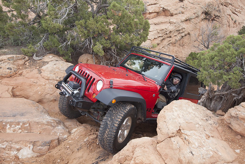
The trail continued to have a series of ledges and stairs peppered throughout its length.
Me trying to get Frank up a slick ledge.
Eventually, the trail opened up with a long ledge essentially splitting the trail into an upper and lower section. Mark led the pack up through a narrow “V” which seemed to be the best line, with the least potential for tippyness.
Mark leading the charge.
After this section, the trail turns to the left and climbs up for some elevation gain. There is a great spot for pictures on the ledge above.
From this section on, we navigated some different ledges and couple of tight sections.
Jesse navigating a tight spot. That’s what SHE said!
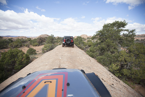
The trail also opened up and followed a very narrow ridgeline of slickrock. Any missteps here would be a rollover.
The narrow ridgeline.
We broke for a quick lunch spot when the trail settled down and opened up, to allow for others to pass us as needed.
After lunch, we made our way toward the fabled “Fall.” The Fall is a 6-7 foot near vertical drop. At the base of this drop, the driver must turn an immediate left, as there is a ravine to the right. Maintaining full control of the vehicle is critical, especially since once gravity takes over, it will slide down the face of the Fall with little control.
Richard taking on the Fall, with Frank the Tank on his 6.
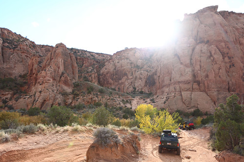
After the Fall was behind us, we were able to appreciate the scenery of the area. The desert floor opened up to some amazing vistas and rock formations.
Jesse posing.Desert scenery.
At this point, the trail began to descend back to the creek drainage we crossed earlier in the day.
The ground became more sand than rock and presented more tree growth which added to the scenery.
The creek drainage scenery.
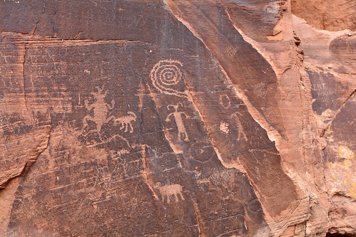
Once over the creek, we decided to check out some ancient petroglyphs/hieroglyphs on a wall. The natural and human history of this area amazes me.
Native art scene.
Once on the road, we stopped at a local pub on our way home for a cold, malted beverage.
![Trail Review: Kane Creek Canyon [UTAH]](https://offroadvegan.com/wp-content/uploads/2014/05/20140516_181539.jpg?w=672&h=372&crop=1)

![Road Trip Day 3: Utah to Oregon [Donuts, Donkeys and Being Home]](https://offroadvegan.com/wp-content/uploads/2014/02/2014-02-18-12-27-12.jpg?w=672&h=372&crop=1)


![Road Trip Day 2: Nebraska to Utah [Wind, Coffee, and Starry Nights]](https://offroadvegan.com/wp-content/uploads/2014/02/20140217_182326_richtonehdr.jpg?w=672&h=372&crop=1)


![Trail Report: Hell’s Revenge [Utah]](https://offroadvegan.com/wp-content/uploads/2013/12/img_8998.jpg?w=672&h=372&crop=1)


![Trail Report: Onion Creek Canyon & Rose Garden Hill [UTAH]](https://offroadvegan.com/wp-content/uploads/2013/12/img_8834.jpg?w=672&h=372&crop=1)


![Trail Report: Steelbender [Utah]](https://offroadvegan.com/wp-content/uploads/2013/11/img_8394.jpg?w=672&h=372&crop=1)