
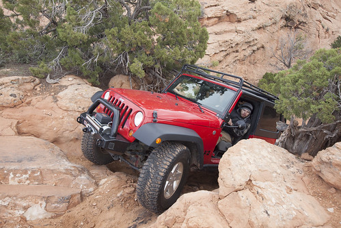
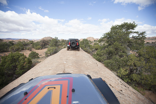
This year’s Rubicon trip would be unlike any other we have ever taken. Maybe it was the seemingly countless trailer flops. Or maybe it was the legendary campsite. Or, the fact we started in Wentworth Springs instead of Loon Lake.
Tag Archives: Trail
![Trail Review: Crushers [OREGON]](https://offroadvegan.com/wp-content/uploads/2015/08/img_2631.jpg?w=672&h=372&crop=1)
Trail Review: Crushers [OREGON]
I always laugh at the often obscure names given to trails in our area. Some, I am sure have a backstory (Stick in the Nose is an actual trail name) while others I think are a lame attempt at sounding intimidating. But Crushers has always had that scary spot in my mind.
Not just due to the name, but due to the massive boulder field that is the trail. It is probably the ultimate rock crawling trail in this area.
The trail begins with a common filter that has a pretty easy line even though it looks menacing.

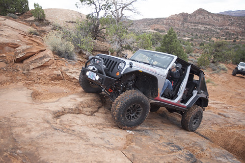
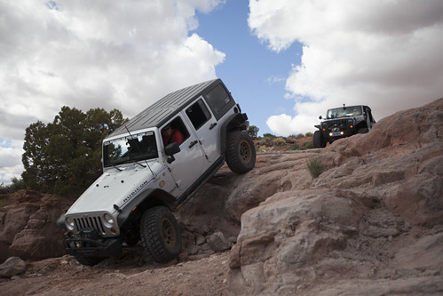
![Trail Review: The Rubicon Trail Part 2 [California]](https://offroadvegan.com/wp-content/uploads/2014/09/day-21.jpg?w=672&h=372&crop=1)
Trail Review: The Rubicon Trail Part 2 [California]
August 2014, Days 2 & 3.
Miss part one? Find it here!
Everyone slowly woke to the familiar smell of coffee and the sound of hushed voices. Once caffeinated and packed up, we decided to cross the dam and take a look at the helicopter crash site.
Just days before we arrived, a chopper that was ferrying supplies for the Jamboree crashed on the shore of Buck Island Lake. Fortunately, everyone survived. It was still a very surreal scene, with bloody clothes visible and even the pilot’s headset resting in the cockpit window frame.

Once we returned to the campsite, we left Buck Island Lake, quickly encountering a fun series of ledges right out of the gate.
Continue reading Trail Review: The Rubicon Trail Part 2 [California]
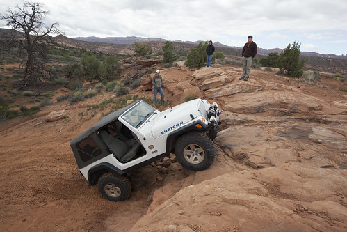
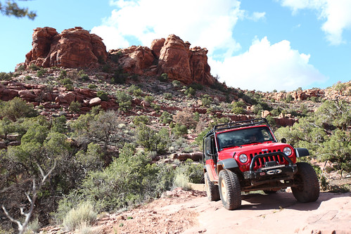
![Trail Review: The Rubicon Trail Part 1 [California]](https://offroadvegan.com/wp-content/uploads/2014/09/part1.jpg?w=672&h=372&crop=1)
Trail Review: The Rubicon Trail Part 1 [California]
August, 2014, Day 1
The Rubicon is not just an offroad trail, snaking through the Sierra wilderness of Northern California. It is also a river in Italy. More importantly, the saying “crossing the Rubicon” is a direct reference to when Caesar’s army crossed this treacherous river, knowing they could never go back. It is now a reference to a point of no return.
And, while there many points along the Rubicon trail that seem like a point of no return, the metaphor is larger than that. The Rubicon is more of a pilgrimage (pardon the oft cliche’d jeeping phrase) for people that are looking to challenge themselves and their Jeeps, spend quality time with great friends, and experience some of the most beautiful wilderness this country has to offer.
As far as the offroad community is concerned, spending time on the Rubicon Trail is a spiritual experience.
So, it is, actually a point of no return.
Continue reading Trail Review: The Rubicon Trail Part 1 [California]

Trail Report: Weekend at Manastash Ridge
Last Saturday, our small convoy of Jeeps left a Starbucks in Vancouver, for the 4 hour drive to Manastash. Leaving at 7:00AM, we made great time on the way North.
We decided to fill up on last minute supplies and top off the tanks at Whistlin’ Jack’s in Cliffdell.

We took the second right after Kaner Flats campground (off FS 19), airing down just off the road before Kaner Flats trailhead (trail 676).
The following images are a collection from that trail.
![Trail Report: Cline Butte Trail #34 [Oregon]](https://offroadvegan.com/wp-content/uploads/2014/04/feat2.jpg?w=672&h=372&crop=1)
Trail Report: Cline Butte Trail #34 [Oregon]
It is not every day you get to pull into an Off Road Vehicle area for the first time. But this morning, we did just that as we decided to visit the Cline Buttes Recreation Area, sandwiched between Redmond and Sisters, Oregon on Rt. 126.

Central Oregon’s drier weather is a welcome change to the recent rain we have been having, and the sandy surfaces of Cline Butte was a nice contrast to the mud at Tillamook State Forest.
Cline Butte was a VERY well organized, and well signed area with plenty of amenities. Forest Management at TSF could learn a thing or two about how to properly run (and sign, and map, etc) an ORV area. We did not get lost once, due in large part to the awesome maps and very well signed network of trails.

After airing down, Jesse, Chris, Melanie and I chatted at Barr North staging area to decide what areas to hit. We warmed up in the open play area (which ended up a giant dump pit full of spent shells, glass, burned wood, etc) and quickly left, making our way to trail 34 – the most difficult trail in the park.

We decided to warm up on a couple of ledges on the outer rim of the open play area. With Chris’ expert spotting, both Jesse and I made it up some of the more technical spots.
Then we moved onto trail #34.
The nice part about this trail is that the difficulty seems to progress as you get further into the trail. The beginning sections are a bit boring, but soon you are encountering more ledges, loose rocks, and challenging terrain.

The sun came out and we broke for lunch about half way into the trail. Lunch was Tofurky sandwiches, Earth Balance popcorn and gatorades.

After our break, the wheeling became really rocky. Many obstacles had multiple options and bypasses.

Toward the end of the trail is a large ledge on the right side of the trail. There is an obvious route up the ledge between two harder options (the easy option is the one with the small pine tree in the center).

If we had more time, I would have attempted the more difficult option on this ledge, to the right of the option pictured above. To the left of above is the most (triple black IMO) difficult option which is probably not doable by very many Jeeps.
About a half mile after the ledge above, we met up with trail #37 which took us straight to the parking area to air up and cruise out.
Overall, Cline Butte was a great change of scenery from TSF. We were not really challenged to the max, but there were some spots that tested our skills. Unfortunately, this was the toughest trail here, so next time will be the same, or some of the simpler trails.
It looks like camping is permitted in the staging area.
![Trail Report: Hell’s Revenge [Utah]](https://offroadvegan.com/wp-content/uploads/2013/12/img_8998.jpg?w=672&h=372&crop=1)
Trail Report: Hell’s Revenge [Utah]
October 16 2013
8:00AM
This trail was on my Moab Bucket List™ for a long time. A few of the climbs look pretty crazy, the views amazing, and conquering the famed “Hell’s Gate” was one of the reasons I came to Moab.

After a quick air down at the parking lot of Hell’s Revenge Jesse, Melanie and I were on the trail by 8:30.
The trail climbs almost instantly right from the staging area. In the first few minutes, you climb up onto a saddle, riding a narrow ridge – this is just a sample of what’s to come. At the base of this, is a narrow sandy area called “Lake Michigan” due to the potential for high water. It was wet on this day, but easily crossable.

The views open up into some pretty spectacular scenery. The trail is predominantly on slickrock with some sandy spots. The first couple of climbs will certainly get your heart rate going, especially when you see them in the distance – they look almost vertical. With a little throttle control and some alertness, it is fine. Continue reading Trail Report: Hell’s Revenge [Utah]
![Trail Report: Onion Creek Canyon & Rose Garden Hill [UTAH]](https://offroadvegan.com/wp-content/uploads/2013/12/img_8834.jpg?w=672&h=372&crop=1)
Trail Report: Onion Creek Canyon & Rose Garden Hill [UTAH]
October 15, 2013
6:00AM
One of my favorite aspects of running trails in Moab is that you can (usually) leave the doors off. Our jeep did not see doors the entire week.
But, this morning was a 6AM departure and a pretty long drive along the Colorado River. It was freezing. Some of the most beautiful scenery I have experienced in a long time. But freezing.


We continued on Route 128 East. After about 40 minutes, the road left the canyon and the river, opening up into a huge desert plateau. We pulled off onto Onion Creek Road where we made a quick bathroom break and to air down. Continue reading Trail Report: Onion Creek Canyon & Rose Garden Hill [UTAH]
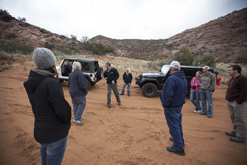
![Trail Report: Steelbender [Utah]](https://offroadvegan.com/wp-content/uploads/2013/11/img_8394.jpg?w=672&h=372&crop=1)
Trail Report: Steelbender [Utah]
October 14, 2013
We started out pretty early, arriving at the trailhead about 8:00AM.
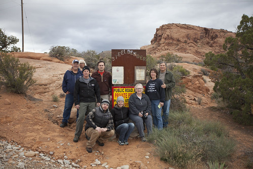
The team posed for a quick photo at the trailhead and we met up with a couple that asked if they could run the trail with us in their Cherokee.
We drove in about 2 miles of pretty easy gravel road with a minor creek crossing, and took a break for a quick driver’s meeting. This was also a great opportunity to meet our new friends.
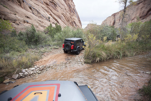
The area we stopped at was a “Driver’s Choice” section with many different lines of attack. I chose what I thought was a challenging ledge and was able to get up reasonably easy, even though the rock surface had some damp sand.
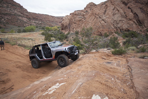
The trail continued to have a series of ledges and stairs peppered throughout its length.
Eventually, the trail opened up with a long ledge essentially splitting the trail into an upper and lower section. Mark led the pack up through a narrow “V” which seemed to be the best line, with the least potential for tippyness.
After this section, the trail turns to the left and climbs up for some elevation gain. There is a great spot for pictures on the ledge above.
From this section on, we navigated some different ledges and couple of tight sections.
The trail also opened up and followed a very narrow ridgeline of slickrock. Any missteps here would be a rollover.
We broke for a quick lunch spot when the trail settled down and opened up, to allow for others to pass us as needed.
After lunch, we made our way toward the fabled “Fall.” The Fall is a 6-7 foot near vertical drop. At the base of this drop, the driver must turn an immediate left, as there is a ravine to the right. Maintaining full control of the vehicle is critical, especially since once gravity takes over, it will slide down the face of the Fall with little control.
After the Fall was behind us, we were able to appreciate the scenery of the area. The desert floor opened up to some amazing vistas and rock formations.
At this point, the trail began to descend back to the creek drainage we crossed earlier in the day.
The ground became more sand than rock and presented more tree growth which added to the scenery.
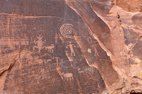
Once over the creek, we decided to check out some ancient petroglyphs/hieroglyphs on a wall. The natural and human history of this area amazes me.
Once on the road, we stopped at a local pub on our way home for a cold, malted beverage.

WHAT CAME IN HANDY:
WHAT WOULD HAVE MADE IT BETTER:
![Trail Report: Archer’s Firebreak [Oregon]](https://offroadvegan.com/wp-content/uploads/2013/11/2013-11-16-11-59-59.jpg?w=672&h=372&crop=1)
Trail Report: Archer’s Firebreak [Oregon]
November 16, 2013
The team met at the typical location – the Chevron station in North Plains around 9:00.
We were on the road by 9:30.
Arriving at the pull out to air down, we quickly let the air out and got on our way.
Getting to the start of Archer’s Fire Break is always long and boring, but the hill shortly after the trail begins is sure to get the grease moving in the gearbox. This first climb through dense green forest and loose, gravelly mud is just a preview of what is to come.
Shortly after the first climb, the group found ourselves conquering an old foe – the “V Notch.” This long, steady climb also has a very angled stance with the passenger often looking at the ground as it passes by. The driver tries not to lose momentum even with their eyes closed. The extreme angle seems like your Jeep is going to tip over at any moment.

The rest of the trail is actually a bit on the boring side. It is a series of small segments that continually intersect with the main forest road.
Many of these segments are just long enough where you can get out of 4WL (or simply be in 6th gear at 4,000 RPMs) only to quickly have to re-engage. Many of these trail segments also are pretty featureless, save for a few deep water fordings in the wet months, or some short rock gardens.

The real coup de gras waits at the end of the trail like a predator stalking its bored and tired prey. The final stretch of this trail is called “Rocky Uphill” for, creatively, both the large number of rocks that litter the path and the fact is in quite uphill.
There are two possible routes starting from the base of RH – the right and left – with the left side being rumored as the easier side. On this trip however, they both seemed equally scaled.
The two options soon merge near the top, where the pitch of the hill steepens, the rocks increase in size, and the driver is again presented with two options: right or left.
Right seemed to be the easier choice. The left side has seen vehicles roll over on previous days (granted it was a Toyota).
After Rocky Uphill, the trail continues with one last technical section, then meets up with the forest road for the drive back to air up and head home.

WHAT CAME IN HANDY:
WHAT WOULD HAVE MADE IT BETTER:

